
Strata of Oblivion
Status: research project in progress. Working notes, preliminary analyses, routes and archaeological questions are published in the Logbook as they advance.
For twenty-six centuries the Spanish Mediterranean coast was a metal-exporting shore. Phoenician and Roman ships sank along it laden with lead ore, and some of those wrecks rank among the most important underwater sites in the western Mediterranean. The Mazarrón II, from the seventh century BC, sank with lead-ore cakes, a miner’s basket, and a granite grinding stone still on board. The Bou Ferrer, from the first century AD, carried lead ingots of exceptional dimensions. Today the same shore receives the bodies of those who cross from territories where extraction continues.
Strata of Oblivion photographs six mainland locations along a 400-km arc where an archaeological wreck and a contemporary migrant shipwreck share coordinates. The selection deliberately avoids the island enclaves that dominate media coverage. This project remains on the mainland shore precisely because the islands have already been made visible and the mainland has not.
Each location is resolved as a quartet in 4:3 format. A long-exposure twilight image, where the silhouette of a ruin or a lighthouse holds the archaeological wreck. A dawn image in low raking light, at the hour when night crossings end. An overexposed zenithal void where sea and sky dissolve and only the horizon remains. And a large detail shot of local matter lit with artificial raking light—volcanic sand, mining slag, salt crystal, or Roman mortar—onto which both sets of coordinates are inscribed through light and shadow, not as a graphic overlay.
A moving-image layer accompanies the photographs. At each location a fixed-frame timelapse is generated by interval capture during the midday band, with no camera movement, no sound, and long intervals between frames. The six timelapses are assembled over a single horizon line, so that the cuts between locations become imperceptible and the 400 km of coast read as one continuous shore. The piece is titled Depositions, a word that names at once geological sedimentation and sworn testimony.
The locations
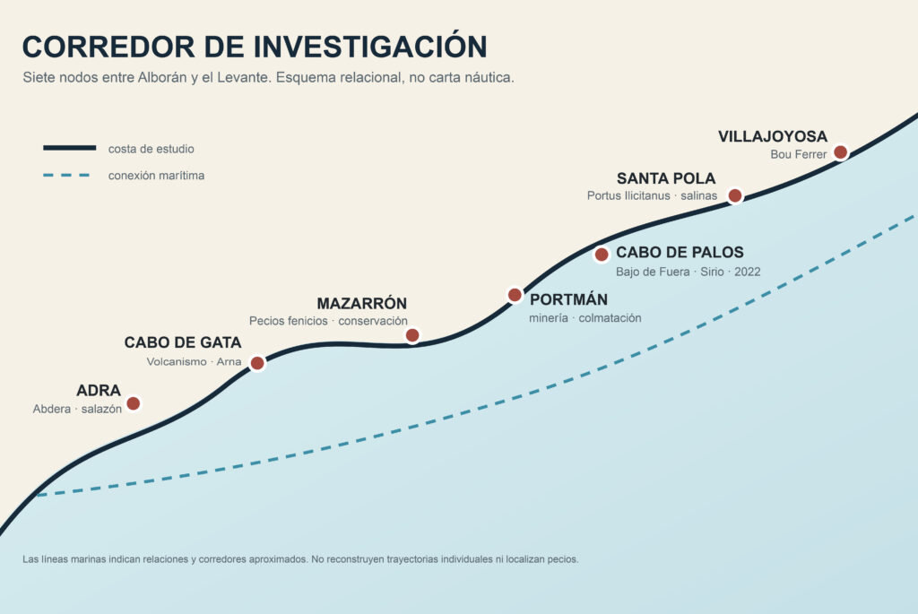
Presented from west to east.
- Adra, Almería. Phoenician Abdera on the Cerro de Montecristo, with a salt-fish factory active until the late-Roman period. Matter: mortar from the salting basins.
- Cabo de Gata, Almería. Wreck of the steamer Arna (1928) against the Laja, Dressel 20 amphorae, and medieval wrecks in the Valle del Sabinar. Four BIC-protected zones declared in 2009. Matter: black volcanic sand and basalt.
- Mazarrón, Murcia. The Phoenician ships Mazarrón I and II (seventh century BC), the most important Phoenician underwater site in the western Mediterranean. Matter: mining slag on the shore.
- Portmán, Murcia. Roman Portus Magnus, a bay buried under mining tailings between 1957 and 1990. Matter: mining tailings, because the beach itself is industrial waste.
- Cabo de Palos, Murcia. Bajo de Fuera, five named wrecks within 3.5 miles, with more than fifty documented shipwrecks in total, including the Sirio (1906), which carried European emigrants to the Americas. Matter: dry compacted Posidonia with microplastics.
- Santa Pola and Villajoyosa, Alicante. Bou Ferrer (first century AD), the largest Roman ship under excavation in the Mediterranean, and Roman Portus Ilicitanus beneath Santa Pola. Matter: salt crystal.
Status note
The project is in a phase of archival research and verification of coordinates against primary sources (Missing Migrants Project, Caminando Fronteras, regional archaeological authorities), prior to the photographic production planned for the winter of 2026–2027.
No finished photograph from the series is presented here, because the project is in preparation. The absence of a finished image forms part of the project’s honest state.